
HISTORICAL ATTRACTIONS
Take a self-guided tour of the Historic Homes in Pawnee County!

BIRTHPLACE OF FARM CREDIT
“In the early 1900s, farmers and ranchers found credit hard to come by. If available, it was often very expensive—as much as 10% per month. In 1916, Congress passed the Federal Farm Loan Act due to the importance of agriculture in our economy. Then, Wichita was granted the first of 12 Federal Land Bank charters nationwide and charged with developing lending programs in Kansas, Oklahoma, Colorado, and New Mexico. In turn, it issued the first local association charter to the Pawnee County National Farm Loan Association of Larned. These 280 acres served as collateral for the nation’s first Federal Land Bank loan made on April 10, 1917 to farmer A.L. Stockwell.”

Camp Criley
“Camp Criley was established in 1872 as a supply station for workmen building the Santa Fe Railroad. The name changed to Garfield in 1873 by pioneers settling here.The park, where the marker resides, was planned in 1880 and the first trees planted in April 1882. The Band Shell erected in the early 1900’s used for many concerts by local musicians. The hitching post and stone stile used in the early days by ladies when mounting their horse brought from the former A.H. Moffet place. [Bricks in base of the sign are from the school building erected in 1884 and made in local kiln.]”
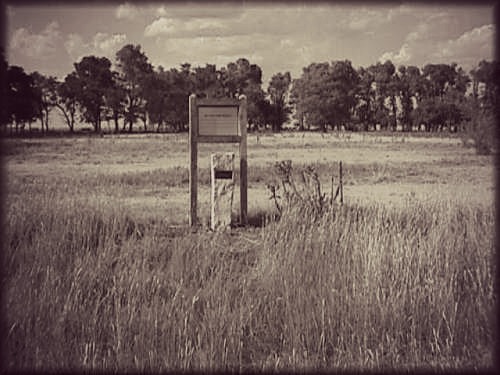
Coon Creek Crossing
“The Coon Creek Crossing marker, located 1.5 miles southwest of Garfield, was placed by the Wet/Dry Route of the Santa Fe Trail Association due to its historical significance. This 46.99-acre site serves as a marker for 1) the last stream to be forded on the wet route by Santa Fe bound travelers, 2) an intersection where Fort Larned merged with the wet route, 3) a stage station established by M. Cottrill Company, and 4) several other noteworthy incidents and conflicts. Coon Creek, which meandered through the area, could be a troublesome crossing point for travelers, and was in an area of considerable hostile Indian activity. If you look carefully, wagon ruts are still visible on the north bank of the creek”

Discoverer of Pluto Historical Marker
“Burdett is the boyhood home of Dr. Clyde Tombaugh, discoverer of the Pluto. He was born in Illinois in 1906, but he grew up on a farm northwest of here and graduated from Burdett High School in 1925. During his youth, Tombaugh explored the heavens with homemade telescopes. Later he was hired by Lowell Observatory in Flagstaff, Arizona, where he discovered Pluto in 1930. During his planet search, Tombaugh photographed 65 percent of the sky and spent 7,000 hours examining about 90 million star images. Besides Pluto, his discoveries included: six star clusters, one cloud of galaxies, one comet, and about 775 asteroids”

“Fort Larned was one of a series of forts along the Santa Fe Trail spaced to provide adequate protection along the entire trail. Fort Larned’s troops patrolled the Santa Fe Trail 70 miles in either direction from the fort, and at some times, escorted wagon trains down the trail to deter attacks. In time, Fort Larned and other forts along the Santa Fe Trail played their part in establishing lasting US control over the Great Plains. Fort Larned is now one of the most complete and best preserved military posts of the Indian Wars era. It’s no surprise the Fort was a finalist for the 8 Wonders of Kansas!”

Garfield Memorial Wayside Chapel
“In 1873, Ohio Congressman James A. Garfield (later the 20th President of the United States) was honored by former citizens from his District by naming their town after him. In appreciation, he gave a bell to the community for the first church to be erected in Garfield. The Congregational Church (built in 1875) was the recipient of the bell. The Wayside Chapel is a memorial to the Church. The stone at the base of this marker is the original step to the first church. Visitors can catch a glimpse of the bell by peering through the door’s window.”

Pawnee Fork Crossing
“There were two crossings of the Pawnee Fork—the south edge of Larned (wet route) and the west edge on the Larned State Hospital campus (dry route). The western route can still be seen and crossed by means of a small bridge. The dry route crossing was difficult at times, so a campsite was developed for travelers to wait for ideal crossing conditions. Later, a mail and stage station was built at the crossing in 1859, which led to the establishment of Fort Larned. The Pawnee Fork Crossing was one of the most hazardous fords on the entire length of the Santa Fe Trail.”

“The Santa Fe Trail Center is a unique educational institution devoted to the interpretation of the historic transportation route known as the Santa Fe Trail. The regional museum and library preserves artifacts and manuscripts related to the blending of the major cultures along the Trail and enhances understanding of the continued development of the Trail. The museum’s collections contain over 35,000 artifacts and various revolving and stationary exhibits.”

Sibley's Camp
“On August 31, 1825, George Sibley described this location as one of the campsites for the Santa Fe Road survey team. In 1995, local history enthusiasts purchased the property and began to renovate it. Buildings, trees, and debris were removed in order to commemorate the historical value of the site. Since then, a self interpretation marker and modified grain wagon have been added to the property. The “cliffs of soft rock” are definitely a site to see in Pawnee County!”
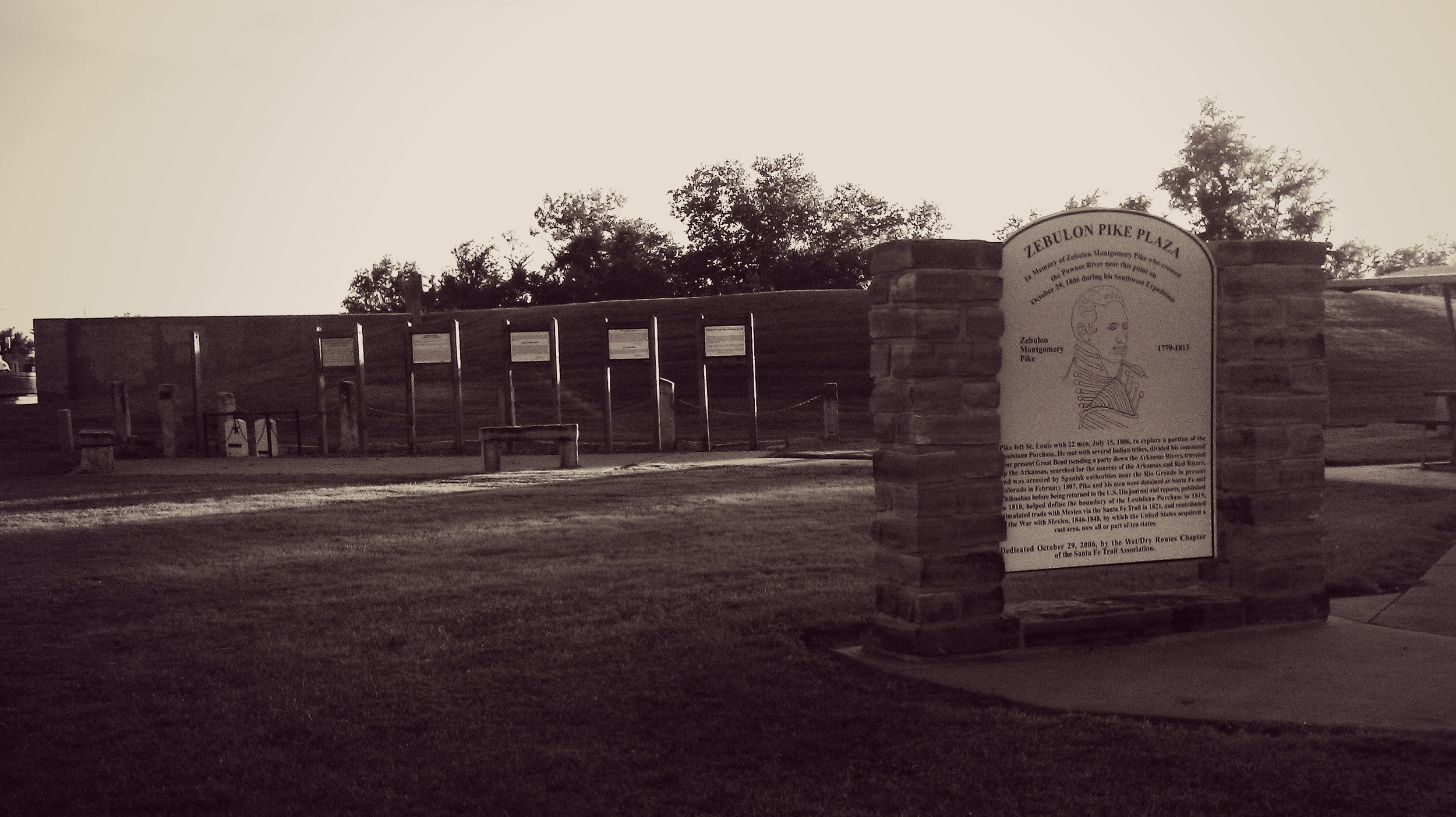
Zebulon Pike Plaza
“Zebulon Pike Plaza, dedicated on October 29, 2006, marks the location where Zebulon M. Pike and his men once camped during the Red River Expedition. This site was originally marked with a simple bronze plaque and two interpretive markers related to the Santa Fe Trail, but was later redesigned by David Clapsaddle. The Plaza now offers several benches, a flag made to look like the 1795 version, a detailed marker telling of the expedition, and two mock gravestones meant to honor two soldiers who died in the Mexican War.”